
Your understanding of Earth's most mysterious continent just became obsolete. While you've been tracking climate change through melting glaciers and rising sea levels, scientists have been staring at a fundamental blind spot: we knew more about the surface of Mars than the landscape buried beneath Antarctica's ice. That changed this week with a discovery that rewrites everything we thought we knew about the frozen continent.
The pattern is unmistakable: for decades, we've been trying to understand Antarctica's fate with incomplete data. Traditional radar surveys left gaps of up to 150 kilometers between measurements - imagine trying to map the Alps with only occasional glimpses from flights spaced miles apart. According to glaciologist Robert Bingham of the University of Edinburgh,
"If you imagined the Scottish Highlands or the European Alps were covered by ice and the only way to understand their shape was the occasional flight several kilometers apart, there's no way that you would see all these sharp mountains and valleys that we know to be there."
Now, researchers have unveiled the most comprehensive map ever created of Antarctica's hidden landscape, revealing a vibrant topography of mountains, canyons, valleys, and plains that has remained unseen for millions of years. The breakthrough, published in the journal Science, used high-resolution satellite observations and a technique called ice-flow perturbation analysis to digitally "strip away" the ice and expose what lies beneath.
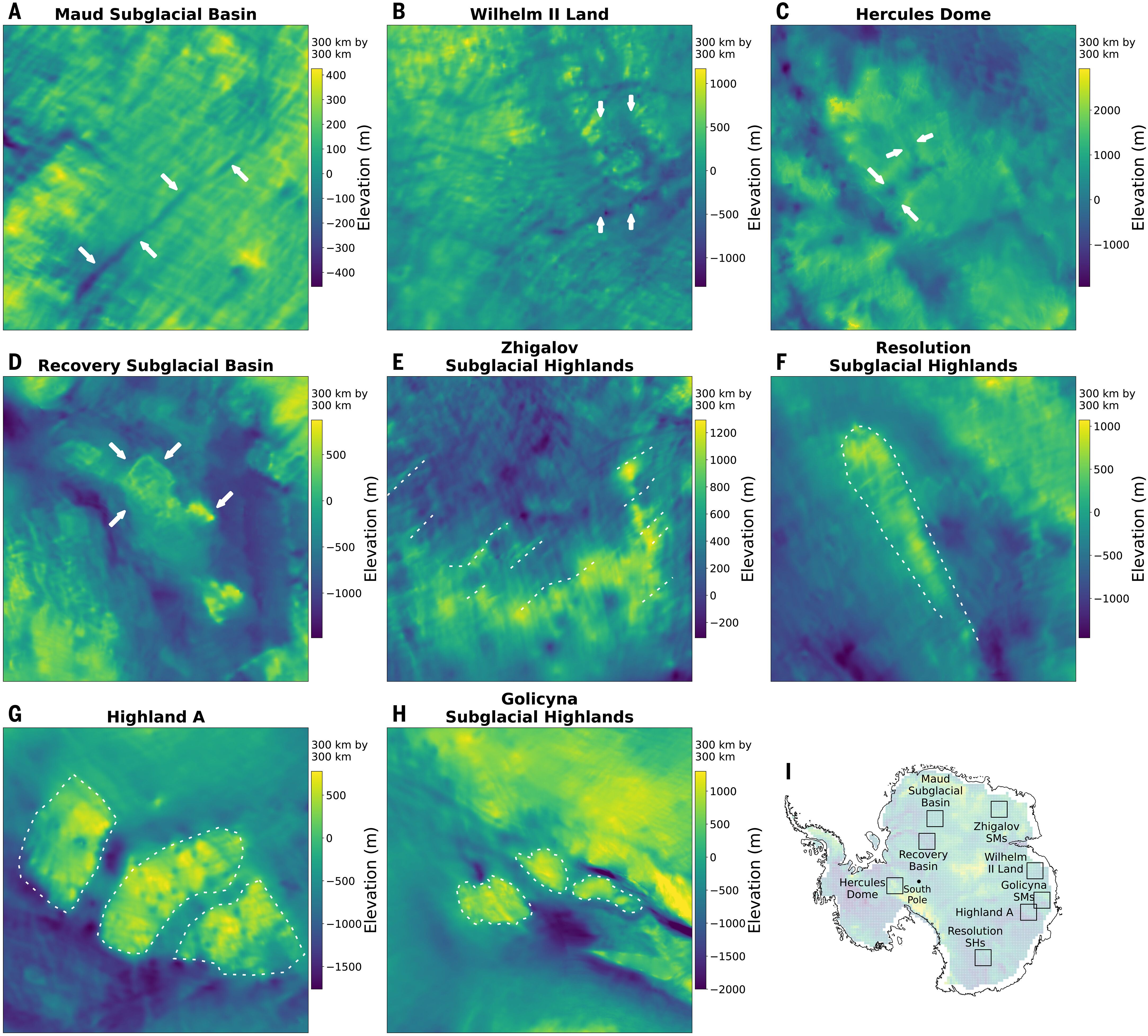
Selected examples of new IFPA subglacial topography
The Scale of What We Didn't Know
The numbers don't lie: Antarctica is about 40% larger than Europe, 50% larger than the United States, and roughly half the area of Africa. Yet until this week, we had better maps of Mars than of this continent's subglacial terrain. The Antarctic Ice Sheet holds about 70% of the planet's freshwater, with ice averaging 1.3 miles thick and reaching up to 3 miles in places. That's enough ice to raise global sea levels by approximately 200 feet if it all melted.
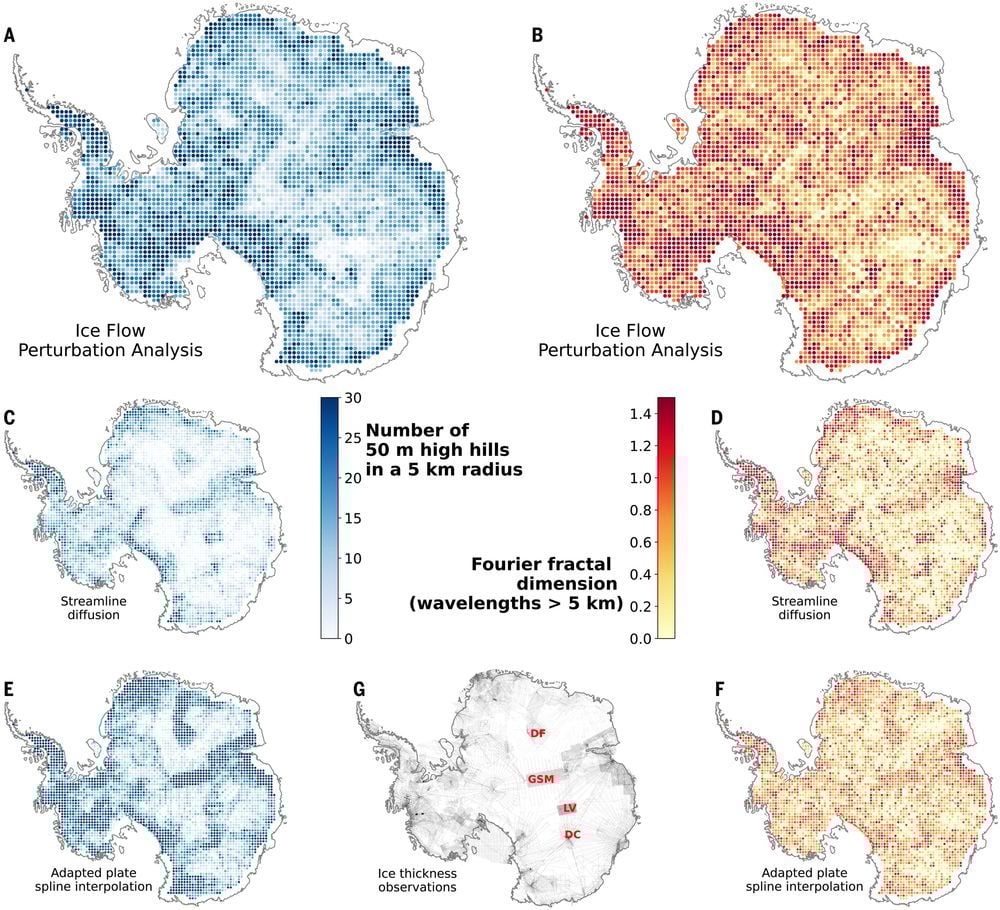
The texture of Antarctica’s ice sheet bed
What the new map reveals is staggering: more than 30,000 previously uncharted hills, each defined as terrain protuberances of at least 165 feet. The landscape includes "high-relief alpine valleys, scoured lowlands, and deeply eroded ice stream troughs" that span hundreds of miles. Lead author Helen Ockenden, a researcher at the University of Grenoble-Alpes, describes the breakthrough in simple terms: "It's like before you had a grainy pixel film camera, and now you've got a properly zoomed-in digital image of what's really going on."
The technology works by combining satellite observations of the ice surface with mathematical models of how ice flows. As Ockenden explains,
"It's a little bit like if you're kayaking in a river, and there's rocks underneath the water, sometimes there's eddies in the surface, which can tell you about the rocks under the water. When the ice is flowing over a ridge or a hill in the bedrock, that manifests in the topography of the surface, but also in the velocity as well."
Why This Changes Everything About Sea Level Predictions
These aren't just interesting geological features - they're critical controls on how Antarctica's ice will respond to climate change. The shape of the bedrock beneath the ice creates friction that slows or accelerates ice flow toward the ocean. Rugged terrain like jagged hillsides and mountain peaks can act as natural brakes on ice sheet retreat, while smooth valleys can become superhighways for glacial movement.
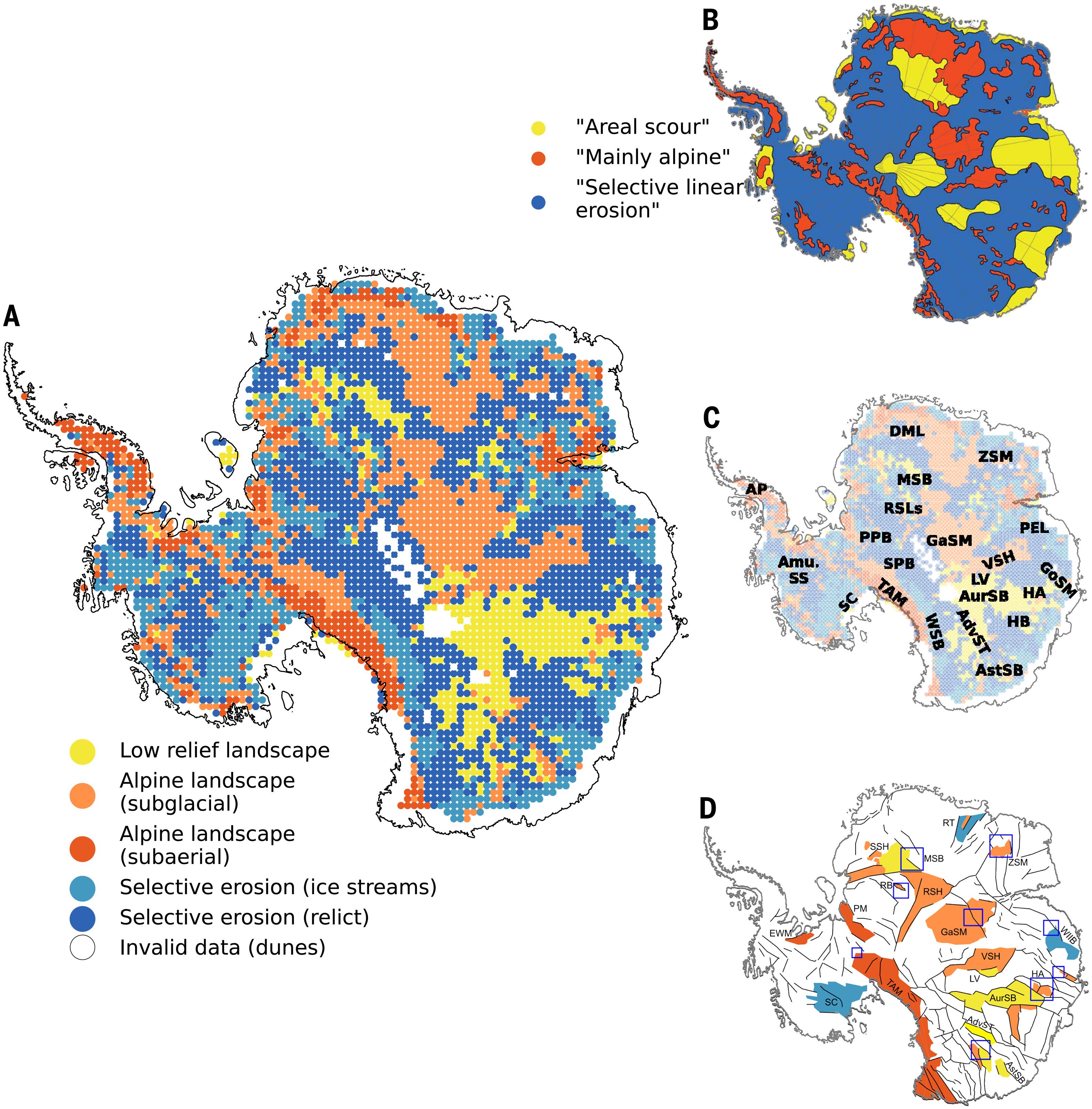
Geomorphological classification of Antarctica’s subglacial landscape
Robert Bingham emphasizes the stakes:
"Having the most accurate map of Antarctica's bed shape is crucial, because the shape of the bed is an important control on friction acting against ice flow, which in turn we need to include in numerical models that are used to project how rapidly Antarctica's ice will flow towards the ocean, melt and contribute to global sea-level rise."
The implications extend far beyond academic curiosity. Previous research has shown that the potential collapse of just one ice sheet - connected to the infamous Thwaites or "Doomsday" glacier - could raise sea levels by dozens of feet in the coming centuries. Scientists discovered that Thwaites' bottom side, once thought to be protected by the seabed, was actually being exposed to warming seawater. Similar revelations about other parts of the continent could dramatically alter our sea level rise projections.
The Historical Context: A Continent That Wasn't Always Frozen
Strip away the ice, and you find a landscape that tells a story of dramatic geological change. Antarctica's subglacial features were sculpted before the continent acquired its icy covering more than 34 million years ago. The continent was once connected to South America before separating due to plate tectonics, and the newly revealed landscape bears striking similarities to regions like Scotland, Scandinavia, northern Canada, and Greenland.
As Bingham notes:
"In every case, all of these continents contain an array of very different landscapes in themselves, from towering mountain ranges to immense flat plains. The hidden landscape of Antarctica also contains these vast extremes. Boring it is not."
The pattern recognition here is critical: we're not just mapping terrain; we're uncovering the geological history of a continent that has been hidden from view for millions of years. The landscape matches so well with known northern hemisphere features that it gives researchers "great confidence in our new map," according to Bingham.
What Happens Next: From Blind Spots to Predictive Power
The strategic calculus is simple: better maps mean better predictions. The researchers hope their work will inform models used by the IPCC (U.N. Intergovernmental Panel on Climate Change) to project future sea-level rise and shape climate-related policies. As Bingham puts it :
"We can now also identify better where Antarctica needs more detailed field survey, and where it does not."
But the implications extend beyond climate modeling. The discovery reveals that Antarctica's landscape is far more complex and varied than previously assumed. The newly resolved topography will help refine projections of ice loss and sea level rise, potentially changing timelines and risk assessments for coastal communities worldwide.
Consider how differently coastal cities from Miami to Shanghai will need to plan their defenses against sea level rise based on these new insights. The question isn't whether Antarctica's ice will melt, but how quickly and in what pattern, questions that now have much clearer answers.
The forward-looking conclusion is both sobering and empowering: we're no longer flying blind over Antarctica. As Bingham told the BBC, "I'm just so excited to look at that and just see the whole bed of Antarctica at once. I think that's amazing."
For the first time in human history, we can see what lies beneath the ice, and that vision could be what saves coastal communities from the worst impacts of climate change.
We've been staring at a continent-sized blind spot for decades. Now we finally have the map.